Utah Map: Regions, Geography, Facts & Figures
Utah is a diverse U.S. state located in the western part of the country, bordered by Arizona, Colorado, Idaho, Nevada, New Mexico, Oregon, and Wyoming. The state is a magnificent place to visit, with a rich history, beautiful landscapes, and numerous tourist attractions, making it a perfect destination for all kinds of travelers. The state also boasts a rich culture and past, with numerous historic sites and landmarks, such as the Golden Spike National Historic Site, which commemorates the completion of the first transcontinental railroad in the United States.
If you want to discover more in-depth information on the Beehive State of Utah, check out our Utah Profile!
Plus, test your state knowledge with our American geography quiz, State Nicknames Quiz!

History of Utah
Utah has a unique and fascinating history, including the early Native American tribes, Spanish explorers, Mormon pioneers, and the discovery of gold and silver.
It was initially inhabited by various Native American tribes, including the Ute, Paiute, and Navajo. The first Europeans to explore the region were Spanish missionaries and explorers in the late 1700s. The territory was later acquired by the U.S. as part of the Treaty of Guadalupe Hidalgo in 1848. Utah became the 45th state of the U.S. in 1896.
The state is also known for its connection to the Church of Jesus Christ of Latter-day Saints, which was founded by Joseph Smith in 1830. The pioneers, led by Brigham Young, settled in Salt Lake City in 1847 and established a prosperous community that still thrives today.
Geography of Utah
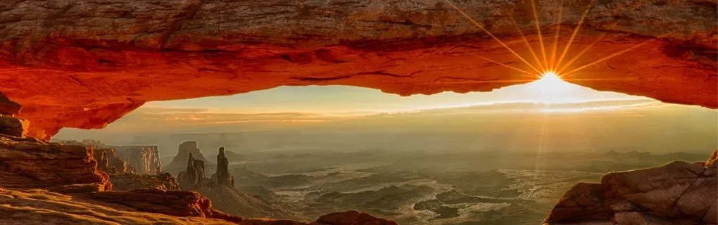
Utah is a diverse state, with a variety of landscapes, including mountains, deserts, and canyons. The political map of Utah is divided into 29 counties, including Utah County, Salt Lake County, and Tooele County. Utah is home to several national parks, including Zion National Park, Bryce Canyon, Arches National Park, and Canyonlands, which provide some of the most breathtaking scenery in the United States.
The Uinta Mountains, the highest range in the state, are situated in the northeastern part of Utah, while the Colorado River flows through the southeastern part of the state.
Tourist Attractions in Utah
The state of Utah offers numerous tourist attractions that cater to different interests. Outdoor enthusiasts can enjoy hiking, biking, skiing, and snowboarding in the state's many parks and recreation areas. History buffs can visit Temple Square in Salt Lake City, where they can learn about the history of the Mormon pioneers. Other popular tourist destinations include Cedar City, Moab, Ogden, Orem, Provo, Layton, Kanab, St. George, and West Valley City.
Brigham City
Brigham City, located in Box Elder County on the Utah county map, is in the northern part of the state. It has a population of approximately 20,000 people and is known for its historic architecture, including the Brigham City Tabernacle and the Brigham City Depot.
Great Salt Lake
The Great Salt Lake in Utah is the largest saltwater lake in the Western Hemisphere, according to the U.S. Geological Survey (USGS), lives in the footprint of the previous Lake Bonneville.[1] The lake is famous for its high salt content, which makes it difficult for fish and other aquatic life to survive. Despite this, the lake is home to several unique species of brine shrimp and other microorganisms.
[1] Great Salt Lake. Usgs.gov. Retrieved June 25, 2023 from https://www.usgs.gov/centers/utah-water-science-center/science/great-salt-lake
National Monuments
Utah is home to some of the most breathtaking national monuments in the world. One of these is the Grand Staircase-Escalante, which is a massive, multi-colored geological formation that stretches across the state. Another iconic site is Bears Ears, which is known for its incredible rock formations and ancient cliff dwellings. Finally, Natural Bridges is another must-see and is home to some of the most beautiful rock bridges in the world.
National Parks & State Parks
Utah's national parks are some of the most popular tourist destinations in the U.S. Zion National Park is known for its stunning red rock formations, while Bryce Canyon offers an otherworldly landscape of hoodoos and spires. Arches National Park features more than 2,000 natural sandstone arches, while Canyonlands offers breathtaking views of canyons, mesas, and buttes. Monument Valley, located on the Utah-Arizona border, is a popular spot for Western movie enthusiasts.
In addition to national parks, Utah also has several state parks, including American Fork Canyon, Wasatch Mountain, and Capitol Reef. These parks offer opportunities for hiking, camping, fishing, and other outdoor activities that you can navigate to with a variety of road maps of Utah or topographic maps of the state.
People Also Ask…
If you're inspecting the physical map of Utah, you may have some queries about the region. Here are some of the most frequently asked questions, along with their answers.
Is Utah a Good Place To Live?
Utah is a great place to live, with its beautiful landscapes, friendly people, and growing economy. The state ranks high in quality of life, job opportunities, and outdoor recreation. However, some may find the culture and climate of Utah challenging.
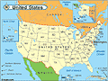
Where Is Utah on the US Map?
Utah is a state located in the western part of the United States, bordered by Arizona, Colorado, Idaho, Nevada, New Mexico, Oregon, and Wyoming. It is home to several national parks, including Zion National Park and Bryce Canyon, as well as the Great Salt Lake.
What Is Utah Famous For?
Utah is famous for its natural beauty, including its stunning national parks and the Great Salt Lake. The state is also known for its connection to the Church of Jesus Christ of Latter-day Saints, skiing, and outdoor recreation.
|
|
 |
Trending
Here are the facts and trivia that people are buzzing about.


