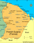
French Guiana (including Inini)

| Status: Overseas Department Prefect: Martin Jaeger (2016) Land area: 34,421 sq mi (89,150 sq km); total area: 35,135 sq mi (91,000 sq km) Population (2007 est.): 203,321 (growth rate: 1.8%); birth rate 20.3/1000; infant mortality rate 11.8/1000; life expectancy: 77.5; density per sq mi: 6 Capital and largest city (2003 est.): Cayenne, 60,500 Monetary unit: Franc Language: French Ethnicity/race: black or mulatto 66%, white 12%, East Indian, Chinese, Amerindian 12%, other 10% Religion: Roman Catholic Literacy rate: 83% (1982 est.) Economic summary: GDP/PPP (2003 est.): $1.551 billion; per capita $8,300. Real growth rate: n.a. Inflation: 1.5% (2002 est.). Unemployment: 22% (2001). Arable land: 0.14%. Agriculture: corn, rice, manioc (tapioca), sugar, cocoa, vegetables, bananas; cattle, pigs, poultry. Labor force: 58,800 (1997); services, government, and commerce 60.6%, industry 21.2%, agriculture 18.2% (1980). Industries: construction, shrimp processing, forestry products, rum, gold mining. Natural resources: bauxite, timber, gold (widely scattered), cinnabar, kaolin, fish. Exports: $155 million (f.o.b., 2002 est.): shrimp, timber, gold, rum, rosewood essence, clothing. Imports: $625 million (c.i.f., 2002 est.): food (grains, processed meat), machinery and transport equipment, fuels and chemicals. Major trading partners: France, Switzerland, U.S., Trinidad and Tobago, Italy (2004). Communications: Telephones: main lines in use: 51,000 (2001); mobile cellular: 138,200 (2002. Radio broadcast stations: AM 2, FM 14 (including 6 repeaters), shortwave 6 (including 5 repeaters) (1998). Television broadcast stations: 3 (plus eight low-power repeaters) (1997). Internet hosts: n.a. Internet users: 3,200 (2002). Transportation: Railways: 0 km. Highways: total: 817 km; paved: n.a.; unpaved: n.a. (1998). Waterways: 3,760 km; note: 460 km navigable by small oceangoing vessels and coastal and river steamers, 3,300 km by native craft (2004). Ports and harbors: Degrad des Cannes. Airports: 11 2004 est.). International disputes: Suriname claims area between Riviere Litani and Riviere Marouini (both headwaters of the Lawa) in French Guiana. |
 |
French Guiana, lying north of Brazil and east of Suriname on the northeast coast of South America, was variously settled by the Spanish, Dutch, and French. The Treaty of Breda awarded France the territory in 1667. The French used it as a penal colony between 1852 and 1939, which included the infamous Devil's Island. In 1947 it became an overseas department of France. Since then, many indigenous French Guianians have called for increased autonomy, although only around 5% favor independence from France, partly due to the vast subsidies from the French government. The European Space Center at Kourou has brought a corner of French Guiana into the modern world and attracted a sizable expatriate workforce.
In July 2005, France and Brazil signed a treaty to build the Oyapock River Bridge over the Oyapock River. The Oyapock River marked Brazil's border with French Guiana. The bridge would be the first land crossing ever, not only between French Guiana and Brazil, but between French Guiana and any part of the world. The bridge was scheduled to open in 2013.
See also Encyclopedia: French Guiana.
| French Overseas Departments | Guadeloupe |
Trending
Here are the facts and trivia that people are buzzing about.


