Weather: Doing the Twist
Doing the Twist
Thunderstorms have a way of going to extremes. If the atmosphere is very unstable and some mechanism is present to evacuate the air rising through a thunderstorm, those upward motions will become even greater. Eventually, thanks to sharp wind variations called wind shear and the spinning Earth itself, the column within the thunderstorm cloud begins to rotate, usually counterclockwise. A funnel drops from the base of the cloud and, when it touches down, becomes a tornado. Winds in a tornado can reach over 300 mph.
Weather-Wise
One of the largest tornado outbreaks on record occurred in 1965 on Palm Sunday. About three-dozen tornadoes spread over five Midwest states. More than 250 people were killed. But even that was topped in April 1974, when nearly 150 tornadoes occurred over 16 states. The death toll reached 307 with 6,000 injured.
Often, a cluster of thunderstorm cells will be rotating when a tornado appears. Those clusters are called mesoscale convective complexes. The individual strong thunderstorms are called supercells. The rotation of these complexes might be the source of the rotation that gets those air columns to do the twist. A tornado is sometimes called a twister or, in the United States, a cyclone. A cyclone, however, is technically any counterclockwise circulation. In the Indian Ocean, cyclones refer to hurricanes.
Tornadoes are powerful, but they're relatively small. They may not be much wider than the length of a football field, although a few might be as much as a mile wide. Most tornadoes will move along a path of a few miles and last just minutes before dissipating, but some have traveled a hundred miles or more. Usually other funnels accompany those long-distance runners, and an entire family of storms will shake loose. The following table shows a commonly used Fujita Scale, which relates damage to tornadoes of different intensities. The scale was named after T. Theodore Fujita, a meteorologist who devoted years to the study of severe weather. Fujita died in November 1998 and has been called "Mr. Tornado."
Fujita Scale
| Scale | Category | MPH | Results |
|---|---|---|---|
| F0 | Weak | 40 to 72 | Branches break, sign posts damaged |
| F1 | Weak | 73 to 112 | Trees snap, windows break |
| F2 | Strong | 113 to 157 | Large trees uproot, weak structures destroyed |
| F3 | Strong | 158 to 206 | Cars overturn, framed structures sustain severe damage |
| F4 | Violent | 207 to 260 | Framed structures flattened |
| F5 | Violent | 261 to 318 | Cars lifted and moved great distances, steel-reinforced structures severely damaged |
The United States has the distinction of experiencing more tornadoes than any other country in the world. Tornadoes have occurred in every state, even Alaska, but the vast majority are unleashed within the Midwest. The following figure shows a map with the average number of tornadoes that have occurred over a 30-year period. The greatest concentration of activity occurs in a swath from Indiana to Texas, then eastward along the Gulf Coast to Florida. A special set of circumstances makes tornadoes more likely to happen here.
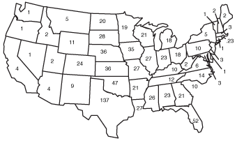
Distribution of tornadoes.
The United States is caught between the cooler weather systems of Canada and the tropical air farther south. Especially during the springtime, some of that warm air pushes northward through Texas and the lower Plains. The air is extremely unstable, packed with warmth and moisture. That volatile air is just waiting for a spark to be delivered. It usually is during the spring, when cold air masses still linger over North America and clash with the surging warmer air.
Weather-Wise
Tornadoes destroy normal wind-measuring instruments, but researchers can now use Doppler radar to measure the wind speed.
This large density difference between the extremes sets the air in motion. The lighter, warmer air is lifted. At the same time, strong winds associated with the pattern appear above the ground, drawing the air away from the top of the rising column. The column continues to destabilize with more warm, moist air rushing upward from the surface. Severe thunderstorms erupt and, eventually, form tornadoes. The following figure gives you an idea how the process unfolds.
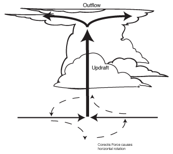
Formation of tornadoes.
Although the spring is the most common time for these vicious storms, they can occur throughout the year. Southern states first experience the action during the winter, the Midwest during the spring, and the northern states during the summer. July is a big tornado month for the Northeast. If conditions favor the development of a damaging thunderstorm, the National Weather Service issues a severe thunder-storm watch. If conditions are expected to be extremely volatile, a tornado watch is posted. When the storm becomes imminent, the watch is upgraded to a tornado warning.
Weather-Speak
Whenever thunderstorms are expected to deliver winds of at least 58 mph and at least 3⁄4-inch hail, a severe thunderstorm watch is issued. If the storm is spotted on radar or observed, it's considered imminent, and a severe thunderstorm warning is posted. If conditions favor tornado development, a tornado watch goes up. If a tornado is sighted, or its signature shows up on radar, a tornado warning is issued with information about where the storm is occurring and its direction of movement.
Excerpted from The Complete Idiot's Guide to Weather © 2002 by Mel Goldstein, Ph.D.. All rights reserved including the right of reproduction in whole or in part in any form. Used by arrangement with Alpha Books, a member of Penguin Group (USA) Inc.
Trending
Here are the facts and trivia that people are buzzing about.


