Weather: Mass Appeal
Mass Appeal
Although the weather is very changeable and always seems to show great variations, there are huge bodies of air that have surprisingly uniform characteristics. These can extend for hundreds, even thousands, of miles and are called air masses.
The temperature and humidity within these air masses will not exactly be constant, but the variations are slight enough so that the air masses can be called warm, cold, dry, or moist. A single air mass offers its own weather. At the same time, when two opposing air masses collide, the weather goes into a spin and the skies open up.
Birth of an Air Mass
Air masses form over particular source areas, taking on the characteristics of the surface over which they form. Air masses develop over polar regions, tropical regions, oceanic areas, and continents. A large high-pressure system is associated with the development of these air masses. In a high-pressure area, the air is diverging—moving away from a particular center. That divergence allows for uniformity—the same air spreads out over a wide area, rather than different air converging toward a particular place. If the air converged toward a center, then different types of air would be on a collision course and great differences in temperature and humidity would occur. But if the air diverges, the mass of air will tend toward uniformity. The following figure shows the source areas of the different air masses.
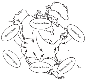
Air mass formation.
In polar regions, clear skies and light winds become important for bringing down the temperature of the air mass. That combination delivers what is called radiational cooling.
It allows heat to escape during the long polar nights. If skies are overcast or if the wind is mixing the air, heat is trapped near the ground, and the air mass will not be able to cool as effectively. The figure below shows how this radiational cooling takes place. The top two diagrams show unfavorable conditions for radiational cooling. Either the atmosphere is cold aloft or the sky is cloudy. But the bottom diagram shows the best conditions when skies are clear, and the warmth near the ground is able to escape.
Weather-Speak
An air mass is a very large body of air that has uniform moisture and temperature characteristics. One air mass can cover one half of the United States.
But while mixing may inhibit air mass formation over the far north, it will help bring moisture into the air. That mixing becomes important for air masses that take shape over the oceans.
Going Hot and Cold
Air masses are given names based upon their source regions:
- Arctic (A)
- Polar (P)
- Tropical (T)
- Equatorial (E)
- Maritime (M)
- Continental (C)
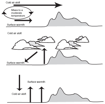
Radiation cooling.
The arctic and polar air masses are cold for a particular time of year, tropical and equatorial air masses are warm, maritime systems are moist, and continental are dry. The arctic systems are colder than the polar air masses and form in the northernmost regions of the earth. The equatorial air masses form over the equator and are the warmest and most humid air masses on the face of the earth.
Weather-Speak
Radiational cooling is cooling that occurs at night. The ground will cool more quickly than the air above it. It is most effective when skies are clear and winds are light.
Then there are the combination platters:
- Continental polar (cP). A polar air mass that forms over the continents.
- Maritime polar (mP). A polar air mass that forms over the oceans.
- Maritime tropical (mT). An extremely humid air mass.
- Continental tropical (cT). An air mass that is desert-dry.
The following table outlines the general type of weather that occurs with the different air masses. The actual weather will be different for different locations, but there are similarities within each air mass. The letter abbreviations are used to indicate air mass type on a weather map.
Air Mass Weather
| Land (Continental) | Water (Maritime) (m) | |
|---|---|---|
| Polar (P) | Cold, dry, stable (cP) | Cool, moist, unstable (mP) |
| Tropical (T) | Hot, dry, stable (aloft) unstable (surface) (cT) | Warm, moist, unstable (usually) (mT) |
Feeling the Chill
Weather-Speak
The lee side is the shore toward which the wind is blowing. If the wind is from the west, the lee side would be on the eastern shore. Local snowstorms form on the lee side of a lake as the cold, dry air picks up moisture from the lake. The air runs into hills and rises. It then releases moisture in the form of snow squalls. This is called the lake effect.
Continental polar air masses usually bring relatively chilly conditions, especially during the winter months. During the summer, a continental polar experience offers a delightful break in heat and humidity. In North America, these air masses form over central and northern Canada and sweep southward. Winds are from the northwest, and the air is dry. Little precipitation will normally fall within these air masses, and skies will at least be partly cloudy. But there are always exceptions.
The major variation on the theme occurs during the winter, when these air masses move over relatively warmer bodies of water, such as the Great Lakes. The cold, heavier air overturns, and that turbulence picks up moisture from the lakes. Then, as this unstable air runs into hills on the lee side of the lakes, the lifting releases the moisture, and heavy bursts of snow, called snow squalls, develop. The intensity of the snow squalls is a function of the difference in temperature between the air and water, as well as the amount of lifting that takes place. These snow squalls can deliver several feet of snow. The process is called the lake effect (see the next figure).
Too Cold for Comfort
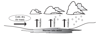
Lake-effect snow.
Arctic air masses have characteristics similar to continental polar air masses, except that they are more extreme. These form near the poles and deliver record cold temperatures. Usually the weather is dry within these air masses, but the turbulence becomes severe over warmer surfaces, and snow squalls can be especially punishing in localized areas. When the lake effect goes to the extreme, snow depths are measured not in feet but yards!
Weather-Wise
In January 1977, the Buffalo, New York, area was especially hard hit when weeks of heavy snow fell during a series of arctic outbreaks. That ice-age month even brought snow to southern Florida. The temperature during that month averaged 10 degrees below normal across much of the eastern states. Glaciers would make a major advance if that temperature departure from normal were sustained over decades.
Occasionally, a strong arctic high-pressure system will form over northern Siberia and then spread across the polar region southward into the United States. That type of weather system is sometimes called the Siberian Express.
By the Sea
Weather-Wise
Hawaii has the distinction of holding the world's record for the largest amount of rainfall, but only on the windward side of Mt. Waialeale.
Maritime polar air masses form over the colder oceans. These can deliver low clouds and fog, but commonly the air sinks within these air masses so that skies clear. The wind is generally onshore. During the summer, these air masses deliver cool conditions to shore areas. Other than some drizzle, the weather is usually precipitation-free when these air masses stand by themselves. Within medium-scale low-pressure systems, this air mass is often tapped for its moisture. But when maritime polar air masses are simply associated with a high-pressure system, the weather is free of rain or snow.
Putting on the Heat
Braving the Elements
During the spring of 1998, a blistering, hot continental tropical air mass developed over central Mexico. Fires flared across Mexico, and smoke spread into Texas. Then that same weather system moved across the gulf states to Florida, where disastrous fires developed. At one point, more than one hundred miles of Interstate 95 was closed to traffic because of the fires. Disaster officials were actually hoping for a tropical storm. The pattern was very unusual for Florida, which normally receives copious summertime rains within maritime tropical air masses.
Tropical air masses either form over the warm, tropical oceans, or over deserts. The moist maritime tropical air masses are steamy with mostly fair weather. But locally heavy thunderstorms can develop when there is some lifting mechanism present. The air is humid and very unstable. The atmosphere is filled with moisture like a sponge. If something occurs to squeeze that sponge, look out! The air could run into a mountain and be lifted. On the windward side of the mountain, the air will rush upslope and pour down. On the opposite side, the air will be sinking, and the precipitation will disappear.
Any mechanism that lifts the tropical air will unleash torrents of rain. But for the most part, the weather in maritime tropical air masses is hazy with sunshine burning through the haze. Dew-point temperatures are generally above 70 degrees during the summer months. These air masses cause great discomfort and are associated with strong high-pressure systems that push northward. The famous "Bermuda High" and the "Azores High" are sources for maritime tropical air. The following figure shows the setup for one of these heat-wave patterns.
In the winter, a surge of maritime tropical air over a cold, snow-covered surface will be responsible for thick fog. Winter thaws always occur when these air masses stream northward.
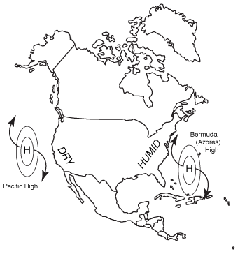
Heat-wave pattern.
How Dry It Is
Continental tropical air masses are extremely hot but dry. These develop over the deserts and can expand into regions such as the Midwest. Skies are clear, and the high-pressure system associated with these air masses can be especially persistent. The great droughts develop within these systems. Sometimes these hot, dry high-pressure areas will appear during the spring over portions of the Plains, and that's a bad sign. As the sun becomes stronger and the summer months arrive, the high pressure itself strengthens. A desert-dry summer then settles across a huge area.
An equatorial air mass is the tropical equivalent of an arctic air mass. It goes to the extreme. It is extremely warm and humid, very much like a maritime tropical system, except more so. The dew-point temperature can reach the incredible 80s in these air masses.
Excerpted from The Complete Idiot's Guide to Weather © 2002 by Mel Goldstein, Ph.D.. All rights reserved including the right of reproduction in whole or in part in any form. Used by arrangement with Alpha Books, a member of Penguin Group (USA) Inc.
Trending
Here are the facts and trivia that people are buzzing about.


