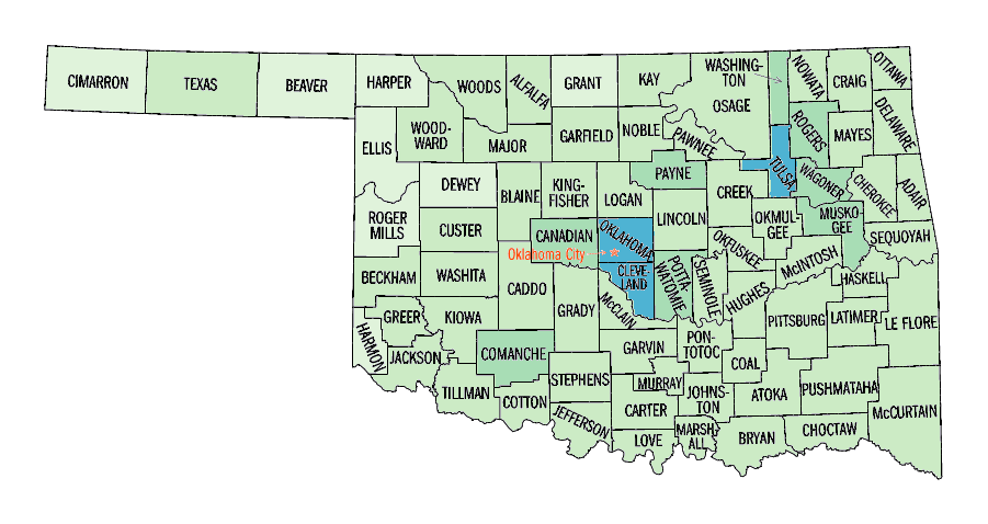
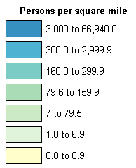
Oklahoma: Persons per square mile, 2000

Ellis County: 3.3Pawnee County: 29.2Mayes County: 58.5Major County: 7.9Tulsa County: 988.2Payne County: 99.4Adair County: 36.5Cherokee County: 56.6Pontotoc County: 48.8Wagoner County: 102.1Garvin County: 33.7Creek County: 70.5Jackson County: 35.4Comanche County: 107.6Coal County: 11.6Pushmataha County: 8.4Atoka County: 14.2Stephens County: 49.4Murray County: 30.2Tillman County: 10.7Logan County: 45.6Kingfisher County: 15.4Dewey County: 4.7Blaine County: 12.9Roger Mills County: 3.0Lincoln County: 33.5Muskogee County: 85.3Okmulgee County: 56.9McCurtain County: 18.6Custer County: 26.5Johnston County: 16.3Oklahoma County: 931.5Carter County: 55.4Cotton County: 10.4Jefferson County: 9.0Choctaw County: 19.8Marshall County: 35.5Bryan County: 40.2Love County: 17.1Love County: 17.1Cimarron County: 1.7Ottawa County: 70.5Craig County: 19.6Nowata County: 18.7Texas County: 9.9Washington County: 117.5Canadian County: 97.4Osage County: 19.7Beaver County: 3.2Sequoyah County: 57.8Okfuskee County: 18.9McIntosh County: 31.4Caddo County: 23.6Haskell County: 20.4Beckham County: 22.0Seminole County: 39.3Pottawatomie County: 83.1Washita County: 11.5Kay County: 52.3Harper County: 3.4Grant County: 5.1Woods County: 7.1Alfalfa County: 7.0Woodward County: 14.9Delaware County: 50.0Rogers County: 104.7Le Flore County: 30.3Noble County: 15.6Cleveland County: 388.1Garfield County: 54.6Grady County: 41.3Pittsburg County: 33.7McClain County: 48.7Hughes County: 17.5Kiowa County: 10.1Greer County: 9.5Latimer County: 14.8Harmon County: 6.1 Persons per square mile, 2000legend

Source information

Old URL
.com/us/census/maps/oklahoma/persons-per-square-mile-2000.html