Portugal: End of an Empire

With the turnover of Macao, the Portuguese colonial empire comes to a close
by Borgna Brunner |
On December 20, 1999 Portugal gave up the last colony in its once vast overseas empire. Macao, the longest permanent European settlement in Asia, reverted to China after 442 years of Portuguese rule. What follows is a catalog of the major Portuguese territories since the 15th century, in order of colonization.
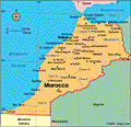 |
Ceuta (1415)
This seaport off Morocco on the Strait of Gibraltar became the first permanent European settlement in Africa and marked Portugal's first attempt at colonization. Ceuta reverted to Spain in 1580, and has remained a Spanish enclave ever since.
The Portuguese prince, Henry the Navigator, took part in the battle for Ceuta, and its exoticism whetted his appetite for exploration and territorial expansion. Henry went on to become a patron of cartography, navigation, and exploration during the 15th century, and launched his country on its way to amassing an extensive empire spanning several continents.
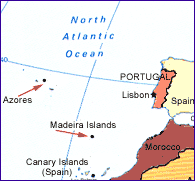 |
Madeira islands
The Madeira islands, 350 miles off the Atlantic coast of Portugal, were originally explored by the Romans. The Portuguese rediscovered the uninhabited islands in 1418–1420 and Prince Henry the Navigator had them colonized. Today the islands are an autonomous region of Portugal.
| |
Azores
Located about 900 miles off the Portuguese coast in the Atlantic, the uninhabited islands of the Azores were encountered by Portuguese sailors in 1427 or 1431. They were first colonized in 1445, and like Madeira, are today an autonomous region of Portugal. The Azores were once used as a place of exile for criminal and political prisoners. In the 20th century, however, the perception of their worth changed significantly—they are now a popular vacation spot. Azore means hawk in Portuguese.
Portuguese Guinea (1446–1447)
Henry the Navigator encouraged the exploration of the west coast of Africa, and from 1444–1446 between 30 and 40 ships headed south in search of slaves and gold. In 1446–1447 Portuguese Guinea, on the west coast of Africa just north of what is now Senegal, was colonized by Portugal and exploited as a source for slaves. It was administered as part of the Cape Verde islands, another Portuguese colony, until 1879, when it became a separate colony. After the Portuguese coup in 1974 installed a government that strongly favored decolonization, Portuguese Guinea became independent in 1975 and was renamed Guinea Bissau.
Cape Verde (1462)
The uninhabited islands of Cape Verde, about 300 miles off the African coast to the west of Senegal, were discovered by the Portuguese in 1456 and colonized in 1462. Slaves were brought to the islands from West Africa, and for a while Cape Verde served as a Portuguese penal colony. Portuguese Guinea (now Guinea Bissau) and the Cape Verde Islands were administered together until 1879. Cape Verde became independent in 1975, a year after the coup in Portugal.
MapTrending
Here are the facts and trivia that people are buzzing about.


