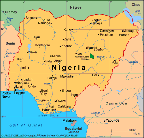
Nigeria Map: Regions, Geography, Facts & Figures
Nigeria is a country located in West Africa that is officially known as the Federal Republic of Nigeria. It is bordered by Niger to the north, Chad to the northeast, Cameroon to the east, and the Gulf of Guinea to the south. Nigeria is the most populous country in the map of Africa, with over 200 million people, and it is one of the largest countries on the continent. Its capital city is Abuja, and its largest city is Lagos. Among the countries of the world, Nigeria is particularly home to an incredible history and culture that date back to prehistoric times.
If you want to discover more in-depth information on Malta as a country, check out our Nigeria Profile!
Plus, test your country knowledge with our world geography quiz on African Flags Part II.
Nigeria Facts: History
Nigeria has a rich history, with evidence of human habitation dating back to 9,000 B.C. The country has been home to several kingdoms, such as the Nok Culture, which flourished between 1,000 B.C. and 300 A.D., and is the earliest known civilization in Nigeria. The country was later ruled by various empires, including the Nri Kingdom, Kanem-Bornu Empire, the Oyo Empire, and the Sokoto Caliphate. These kingdoms had unique art, architecture, and traditions that can still be seen today in various parts of the country
In 1914, Nigeria became a British protectorate, and it gained independence in 1960. Since then, Nigeria has faced political instability, including a civil war from 1967 to 1970. However, the country has managed to overcome these challenges and has emerged as one of the leading African countries.
Nigeria Facts: Geography
Nigeria is located in west Africa and covers an area of 923,768 square kilometers. It is home to diverse landscapes, including the Niger River, the Benue River, and the Chad Basin. The country shares borders with several African countries such as Niger, Chad, Cameroon, and Benin. The Gulf of Guinea is located to the south of the country. Lagos, Kano, and Ibadan are some of Nigeria's major cities. The country's highest point is Chappal Waddi, which stands at 2,419 meters, and is found in Taraba state.
According to the Administrative Map of Nigeria, the country is divided into 36 states and one Federal Capital Territory, which is Abuja.
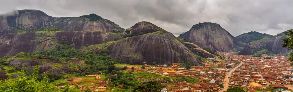
Nigeria is a country with a diverse landscape that is home to many natural wonders and tourist attractions. The country is also known for its cultural heritage, which is reflected in its historic sites and landmarks.
Nigeria Facts: Tourist Attractions
The map of Nigeria is home to several tourist attractions that range from natural wonders to historic sites. The country has something to offer for every tourist, making it a must-visit destination for anyone interested in exploring Africa. Here are some of the top tourist attractions in Nigeria:
- Lagos: Lagos is Nigeria's largest city and one of the fastest-growing cities in Africa. It is home to several attractions, including the National Museum Lagos and the Nigerian National Theatre. Lagos is also known for its beaches, such as Elegushi Beach, and its nightlife.
- Abuja: Abuja is Nigeria's capital city and is home to several government buildings and embassies. It is also a popular tourist destination, with attractions such as Aso Rock and the Nigerian National Mosque.
- Port Harcourt: Port Harcourt is a city located in the Niger Delta region of Nigeria. It is known for its oil industry and is a gateway to many of Nigeria's natural attractions, such as the Bight of Benin and the Niger Delta swamps.
- Benin City: Benin City is the capital of Edo State and is known for its rich cultural heritage. The city is home to the Benin National Museum and the Oba's Palace, which is a UNESCO World Heritage Site.
- Jos: Jos is a city located in the middle belt region of Nigeria. It is known for its cool climate and scenic beauty, with attractions such as the Jos Wildlife Park and the National Museum of Nigeria.
- Maiduguri: Maiduguri is the capital city of Borno State and is located in the northeast region of Nigeria. It is known for its rich history and culture and is home to several historic sites, such as the Shehu of Borno's Palace and the Maiduguri Museum.
- Other major cities in Nigeria include Katsina, Bauchi, Ondo, Enugu, Osun, and Ekiti.
People Also Ask...
If you're inspecting the Nigeria country map, you may have some queries about the region. Here are some of the most frequently asked questions, along with their answers.
Which Is the Largest State in Nigeria?
The largest state in Nigeria by landmass is Niger State, which covers an area of 76,363 square kilometers. However, in terms of population, Lagos State is the largest, with an estimated population of over 21 million people.
What Is Nigeria Known For?
Nigeria is known for its history and culture, diverse landscapes, and natural wonders, including Lagos, Abuja, and Port Harcourt, and is a gateway to many of Africa's other destinations. Nigeria is also known for its oil industry and its status as the most populous country in Africa, as well as Nollywood movies.
How Many States in Nigeria?
Nigeria is divided into 36 states and the Federal Capital Territory, based on the political map of Nigeria. Each state has its own unique culture, history, and traditions, and is governed by a state governor and legislature.
Think you have what it takes?
Show off your geography knowledge with our quiz on the flags of Africa.
|
|
 |
Trending
Here are the facts and trivia that people are buzzing about.


