Hurricanes by the Numbers (Atlantic hurricane statistics)

Millions live in the paths of the biggest storms
Source: U.S. Census Bureau
 Related Links |
The North Atlantic hurricane season begins June 1 and lasts through Nov. 30.
5
The number of types of weather-related events—hurricanes and tropical storms, wildfires, flood outlook areas, disaster declaration areas and winter storms—that the Census Bureau's OnTheMap for Emergency Management tool tracks. OnTheMap for Emergency Management provides reports on the workforce and population for current natural hazard and emergency related events.
11
The number of years since the U.S. was struck by a major hurricane (Category 3 or higher). The last one was Hurricane Wilma in October 2005 over Southwest Florida.
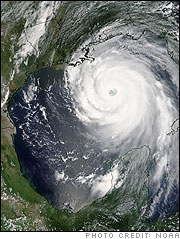
In the Hurricane's Path
4
The number of hurricanes during the 2015 Atlantic hurricane season. During the 2015 season, seven named storms did not materialize into hurricanes.
185
The number of coastline counties along the Atlantic (129 counties) and Gulf of Mexico(56 counties) most threatened by Atlantic hurricanes.
59.2 million (59,260,794)
Population as of July 1, 2015, of the 185 coastline counties stretching from Maine to Texas. In 2006 the population of these counties was 54.6 million (54,510,441). That is an increase of about 4.8 million (4,750,853), or 8.7 percent.
13.0%
Percentage growth of the population of the 98 coastline counties stretching from North Carolina to Texas between 2006 and 2015. These counties grew from 23.9 million (23,892,104) in 2006, to 27.0 million (26,994,043) in 2015; a numeric increase of 3.1 million (3,101,939).
750,919
Collective land area in square miles of the states stretching from Maine to Texas.
3,700
The number of miles of coastline from Maine to Texas.
143.6 million
Population as of July 1, 2015, of coastal states stretching from Maine to Texas ? the areas most threatened by Atlantic hurricanes. An estimated 44.7 percent of the nation's population lives in these states. In 2006, the population of these states was 131.3 million, or approximately 44.0 percent of the nation's population.
9.34%
Percentage growth of the population of the states stretching from Maine to Texas between 2006 and 2015.
60.1 million
The number of housing units as of July 1, 2014, of the coastal states stretching from Maine to Texas. An estimated 44.9 percent of the nation's housing units are located in these states. In 2006 the estimated number of housing units was 56.5 million.
3.3 million
The number of business establishments in 2013 in the coastal states stretching from Maine to Texas. There were 52,323,085 paid workers in these establishments.
Emergency Preparedness
51.5%
The percentage of U.S. homes that have a prepared emergency evacuation kit. The level of preparedness varies by metro area, with about 70 percent of households in the Miami and Tampa, Fla., metro areas having emergency supplies readily available in the event of an evacuation. The Austin (Texas), Chicago and Minneapolis metro areas had among the lowest rate of homes with an emergency preparedness kit. The rates for Austin, Chicago and Minneapolis were not significantly different from one another.
54.3%
The percentage of U.S. homes that have an emergency water supply.
82.0%
The percentage of occupied housing units that have enough nonperishable emergency food to sustain everyone for three days.
69.7%
The percentage of homes where the occupants said they would likely stay with relatives or friends during a two-week evacuation to a safe place that was at least 50 miles away. This was followed by staying at a hotel or motel (18.1 percent) or public shelter (4.1 percent).
48.4%
The percentage of U.S. homes with at least one pet. Of the 56 million homes with a pet, 26.8 percent need help evacuating or sheltering pets while 72.6 percent do not need assistance.
77.5%
The percentage of occupied housing units that have a house or building number clearly visible.
History of Hurricane Naming Conventions
Alex
The name of the first Atlantic storm of 2016. Hurricane names rotate in a six-year cycle with the 2016 list being a repeat of the 2010 names. The names Igor and Tomas were retired from the 2010 list and were replaced with Ian and Tobias.
78
The number of Atlantic hurricane and tropical cyclone names officially retired by the World Meteorological Organization. Although hurricane names are recycled every six years, for reasons of sensitivity, hurricanes and tropical storms that were so deadly and costly that re-use of the name would be considered inappropriate are retired.
1950
The year the Weather Bureau officially began naming hurricanes.
2005
In one of the busiest Atlantic hurricane seasons on record, 28 named storms formed, forcing use of the alternate Greek alphabet scheme for the first time. When the National Hurricane Center's list of 21 approved names runs out for the year, hurricanes are named after Greek letters. Of the 28 named storms in 2005, 15 were hurricanes in which seven were major (Category 3 or higher). Four hurricanes reached Category 5 status (Emily, Katrina, Rita and Wilma).
2013
Despite preseason forecasts for an active hurricane season, that year had the fewest Atlantic hurricanes since 1982. While the year had a slightly above-average number of named storms (14), only two of these storms became hurricanes. For the first time since 1994, no hurricane reached major hurricane strength (Category 3 or higher). No hurricanes and only one tropical storm, Andrea, made landfall in the U.S., causing one fatality.
Trending
Here are the facts and trivia that people are buzzing about.


