Weather: Satellites—a Far-Out Look
Satellites—a Far-Out Look
If a picture is worth a thousand words, then weather satellites have proven their worth time and time again. After all, more than 70 percent of the earth is covered by oceans. Before satellite information became available, storms could go undetected for days before being reported. Ships always provided useful data, but satellites now fill huge gaps. Also the newer satellites serve as powerful clearinghouses for vast amounts of data—not just photographs, although that's how it all got started.
A picture of the first weather satellite, TIROS 1, launched on April 1, 1960, is shown in the following figure. TIROS (Television and Infrared Observation Satellite) was equipped with TV cameras and radiometers, which measured the infrared radiation given off by the earth and atmosphere. That radiation indicates something about temperature because higher temperatures will emit longer wavelengths of energy. But the cloud pictures were essentially snapshots and pretty basic. While the photographs revealed the location of storms and indicate atmospheric wind and circulation, the general strength of a rain-bearing system couldn't be well determined. There were few shades of gray. What the camera saw is what you got. Also the early satellites were rotated to maintain stability, and for 75 percent of the time, the rotation pointed the camera away from the earth. Pictures could only be taken for six hours each day.
TIROS orbited the earth at an average height of 400 miles and made a complete circuit in 100 minutes. Because of the angle of its orbit, it could take pictures both north and south of the equator. Regardless of the limitations, thousands of pictures were transmitted back to Earth by TIROS 1, which operated for 79 days.
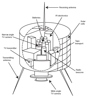
TIROS 1: First weather satellite.
Nine versions of TIROS were launched between 1960 and 1965. Then toward the end of the TIROS era came a new and improved version called Nimbus. Infrared cameras now allowed for more than just visible photography. Clouds could be examined and recorded in detail and at night.
The infrared photography measures the strength of radiation being emitted by a cloud top. Warmer clouds give off more energy. Warmer clouds are the lower ones. Colder, higher clouds give off less energy. The system is programmed to show this difference in reverse. The taller clouds appear brighter than the lower, warmer ones. Presumably the taller clouds are thicker and evidence of more precipitation, but that's not always the case.
A veil of high, thin cirrus clouds appear very brightly on the infrared image. With straight visible images, brighter clouds indicate thicker clouds because of the increased reflectivity from a thicker mass of moisture.
Another problem with infrared imagery is that it can't differentiate between a very low cloud and the surface of the earth when both are at the same temperature. Often the weather appears to be crystal clear on the infrared imagery, but the visible image is completely different. A weather forecaster really needs those visual images, along with the advanced infrared pictures. The infrared provides for nighttime viewing of clouds and delineates the clouds into numerous shades. The infrared photographs can be computer-enhanced to show the range of clouds present, which becomes helpful in locating the heaviest precipitation and most violent weather within a storm. But those pictures can't stand alone.
Weather-Wise
The main role of many of the early weather satellites was simply to look at the weather and to give us cloud pictures.
During the 1960s, satellites were launched into both equatorial and polar orbits. The polar-orbiting satellites are at an altitude of just 530 miles and go around once every 100 minutes. The orbits shift westward by 15 degrees after each pass. The shift allows them to photograph the entire earth twice each day. Because of their low altitude, they can show great detail, down to a resolution of about 0.5 miles. Satellites that orbit around the equator are at a much higher altitude of 22,300 miles, so they can photograph a wider region—but the resolution decreases, and they can't detect objects under 2.5 miles across.
Weather-Speak
GOES, or geostationary satellites, orbit the earth but remain in a fixed place because they revolve around the earth at the same rate as the earth rotates.
Soon after the Nimbus versions were launched, a whole new generation of satellites was put into operation. The first was launched in 1966, 22,300 miles up and directly over the equator. The satellite orbited the earth at the same speed at which the earth rotated, so it appears to remain fixed over a particular point. These were aptly called geostationary satellites, or GOES. The high altitude is necessitated by the requirement of a speed of revolution to match the earth's rotation, and that distance results in a loss of resolution.
Still GOES imagery has become the mainstay of modern meteorology. Over the decades, new and improved versions of GOES have been launched. These satellites provide continuous coverage of cloudiness over the same region of the earth's surface. The satellite transmits the data as quickly as the picture is taken. Cloud movies or loops can be put together, and the development of storms can be monitored. The GOES system takes both visible and infrared images.
Excerpted from The Complete Idiot's Guide to Weather © 2002 by Mel Goldstein, Ph.D.. All rights reserved including the right of reproduction in whole or in part in any form. Used by arrangement with Alpha Books, a member of Penguin Group (USA) Inc.
Trending
Here are the facts and trivia that people are buzzing about.


