Weather: What About the Five-Day Forecast?
What About the Five-Day Forecast?
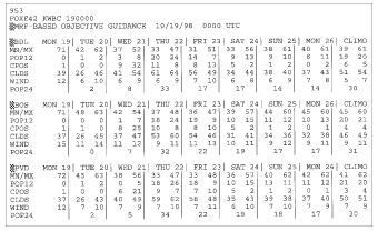
Check out the following figure, which is—a computer projection for not just the next five days, but the next seven. We'd be happy this early Monday morning to get the next two days correct, but everyone likes to look into the distant future, and we have some products that can be put to reasonably predictive use. This particular model is called the MRF—Medium Range Forecast. The name implies that even longer-range forecasts are available. In fact some generalized trend forecasts are available out to 13 months! But for the next five days this MRF gives some useful results.
In the next figure, each day contains a minimum (MN) and maximum (MX) temperature forecast. On Tuesday, the high temperature for Hartford (BDL) is given as 62 degrees, the morning low is 42. Boston (BOS) and Providence (PVD) are also shown. Notice how the temperature drops through the week—just as we expected from our other data. By Thursday, the high temperature for BDL is given as 47 degrees. The normals are listed in the last two columns under "CIIMO." The pre-diction of 47 degrees is much lower than the normal 61 degrees. So when I go on the air, I'll be talking about the chilly turn in a big way.
Medium Range Forecast (MRF), Long Range Forecast.
Other useful data is the 12-hour precipitation probability (POP12) and the 24-hour precipitation probability (POP24). Any probability above the "Climo" number implies some precipitation is possible. But for now we can see that the chances for precipitation through the next seven days are slight, except for Wednesday, and the number is just barely above the "Climo" value. I would predict no more than isolated, light showers for Wednesday. My five-day graphic would show plenty of sun, little or no rain, and a definite cooling trend. I may tweak the MRF numbers a bit, based on experience, but any good forecast will come within the ballpark of this output.
Weather-Wise
An operational forecast is the final forecast product.
Are We Ready?
I think so. I've gathered local data, examined radar and satellite information, checked out numerous charts, and consulted with the oracle of the computer. There are other useful maps, but for this forecast, we've seen enough.
Let's go into the studio—not that I have a choice. It's 5 A.M., and we're going on the air!
Excerpted from The Complete Idiot's Guide to Weather © 2002 by Mel Goldstein, Ph.D.. All rights reserved including the right of reproduction in whole or in part in any form. Used by arrangement with Alpha Books, a member of Penguin Group (USA) Inc.
Trending
Here are the facts and trivia that people are buzzing about.


