Weather: Droplet to Drop … How Rain Happens
Droplet to Drop … How Rain Happens
In "Partly to Mostly Cloudy," we discussed how clouds form. Our next challenge is to understand how clouds turn into rainmakers. Thanks to those microscopic condensation nuclei, clouds form. Condensation allows droplets to grow to a size of about .001 inch, or about .002 centimeter. But a raindrop can be a hundred, even a thousand times larger. Cloud droplets have a lot of growing to do to approach rainmaker status. It takes about one million cloud droplets to deliver a single raindrop. If the relative humidity is high enough, those droplets could grow to a full-size drop.
Weather Words
"The big rain comes dancing to the earth." —Lord Byron
But there is a problem with the obvious. Those cumulus clouds could grow into a rip-roaring downpour within an hour. Yet, the condensation process alone would take days to generate drops large and heavy enough to fall. Something else is needed. If no other process was at work, we might have clouds, but we would never have rain. Water, water everywhere, but not a drop falls down. We need to find a process that will allow droplets to grow at least a hundred-fold in the time frame of a single hour.
Let's See What Sticks
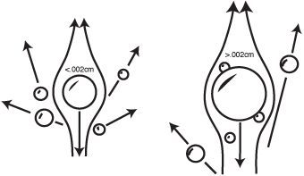
Air stream over droplets.
Weather-Wise
In an extreme cloudburst, rain can be falling at a rate of 4 inches per hour. Normal heavy rain falls at a rate of 6⁄10 of an inch per hour. Moderate rain falls at .15 inch per hour. Light rain falls at .04 inch per hour. Drizzle will fall at a rate of only .01 inch per hour.
One natural rainmaking process involves the joining together, or coalescence, of the small droplets. Little droplets stick together and become bigger droplets, until they're heavy enough to fall to the ground. That sounds easy enough, but because of the way air streams around small objects, if the droplets are less than .002 centimeter, the efficiency of collision becomes very small. The figure shows that air stream. A large droplet might approach a smaller one, but it does not necessarily collide because of the air motion, especially if the large droplet isn't much bigger. The smaller one just deflects the bigger one. Unfortunately, in most clouds over land areas, only one in every 10 million droplets is initially at that .002 centimeter threshold level. Over the oceans, giant salt nuclei do generate larger cloud droplets, and coalescence works quite well. But over land masses, where most of us live, it would never rain. So … why does it rain?
Ice to the Rescue
Ice acts as a magnet for water vapor. Ice really is nice. When ice crystals are around, water vapor thinks the relative humidity is 10 to 20 percent higher than when just water droplets are in the neighborhood. Toss ice into a cloud. Suddenly the pressure of the vapor becomes so great that it simply rushes onto the surface of the ice. The crystal grows rapidly—until it becomes sufficiently heavy to fall. It could melt during descent. If so, it would turn into a large droplet that more easily coalesces with smaller ones. The ice crystals get the droplet to grow initially. Then coalescence takes over.
Weather-Speak
Coalescence is the joining together of small droplets into larger droplets.
Is There Enough Ice?
Well, not exactly. (There's always a problem, isn't there?) Water droplets don't form ice just because the temperature is at 32 degrees Fahrenheit or 0 degrees Celsius. If the droplets are microscopic, they can stay in liquid form at temperatures as low as 40 below; which, by the way, is where the Fahrenheit temperature scale matches the Celsius one. Clouds aren't necessarily cold enough. Ice may be just what we need for droplet growth, but there appears to be a shortage of ice within clouds. But come on! It does rain. So something else must be going on.
Fortunately for reservoirs and wells, that 40-below-freezing threshold only exists for pure water—and since when is water really pure? Thanks to suspended particles, the temperature at which liquid droplets freeze within clouds is closer to 12 below Celsius or 10 degrees Fahrenheit, which is far more attainable at cloud elevation. So then it rains! But if the atmosphere were absolutely crystal clear and pure, it simply would never rain.
Weather-Wise
The first person to break the ice on this theory was Alfred Wegener, of continental-drift fame, in the early 1900s. In the 1930s, it was refined by Swedish meteorologist Tor Bergeron. Within a few years, German meteorologist Walter Findeison made additional contributions. So the ice-nucleation theory has become known as the Wegener-Bergeron-Findeison process. Sometimes it's called the Bergeron process for short.
Excerpted from The Complete Idiot's Guide to Weather © 2002 by Mel Goldstein, Ph.D.. All rights reserved including the right of reproduction in whole or in part in any form. Used by arrangement with Alpha Books, a member of Penguin Group (USA) Inc.
Trending
Here are the facts and trivia that people are buzzing about.


