Chile Map: Regions, Geography, Facts & Figures
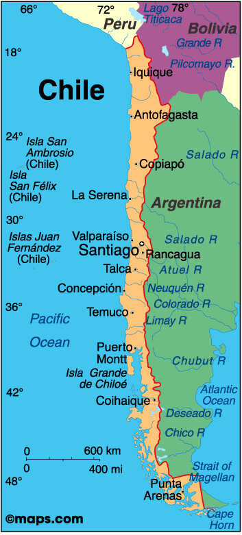
Chile, or the Republic of Chile, is a fascinating country situated in South America, sharing its borders with Argentina, Peru, and Bolivia. With its diverse landscapes, ranging from the Atacama Desert in the north to the Andean mountains in the east, and the Pacific Ocean to the west, Chile is a country that boasts unique geographical features. The capital city of Santiago is the country's largest city, with a population of over 7 million people. Chile is also known for its rich history, culture, and beautiful national parks.
If you want to discover more in-depth information on Chile as a country, check out our Country Profile!
Plus, test your country knowledge with our world geography quiz, Can You Name These South American Landmarks?
History of Chile
Chile has a very interesting history, starting from the time of its first inhabitants, who were various indigenous tribes that lived there before the arrival of the Spanish in the 16th century. The country gained its independence in 1818 and has since undergone various political and economic changes, which have contributed to its growth and development. Today, Chile is a republic with a strong economy, and as a result, it is one of the most prosperous countries in South America.
Geography of Chile
The physical map of Chile is divided into three main regions, each with its unique features, namely: the Andes, the coast, and the central valley. The awe-inspiring Andes run along the eastern border of the country like a topographic boundary, with many peaks over 6,000 meters high, making it an ideal destination for mountain climbers and hikers.
The coast has many major cities such as Valparaíso, Concepción, and Antofagasta, and includes popular tourist destinations such as Easter Island and Robinson Crusoe Island. The central valley is where the majority of Chileans live and is known for its wine production, making it a popular spot for wine lovers. Chile is also home to the Atacama Desert, the driest desert in the world, and Patagonia, a region known for its stunning glaciers and plateaus.
Los Lagos
Los Lagos is a region located in the south of Chile and is known for its beautiful lakes and national parks. Visitors can explore the region through hiking, camping, and other outdoor activities.
Tierra del Fuego
Tierra del Fuego is an archipelago located at the southern tip of South America, separated from the mainland by the Strait of Magellan. It is divided between Chile and Argentina and is known for its rugged landscapes, including glaciers, mountains, and forests.
Cape Horn
Cape Horn is located at the southernmost tip of South America, south of Tierra del Fuego. It is approximately 600 nautical miles (1,100 km) north of Antarctica, and is the southernmost point on the map aside from Antarctica itself.
Magallanes
Magallanes is a region located in the southernmost part of Chile and is known for its natural beauty and stunning landscapes. Visitors can explore the area through hiking, camping, and other outdoor activities.
Tourist Attractions in Chile
A gem on the map of South America, Chile has many tourist attractions that are worth exploring, including the following highlights of any travel guide.
One of the most iconic sites on travel maps, Easter Island is a small island located off the coast of Chile and is known for its mysterious statues and rich history. Visitors can explore the island's archaeological sites and learn about its unique culture. There are many other activities that visitors can participate in when they visit Easter Island.
- Valdivia: Valdivia is a beautiful city located in the Biobío region of Chile. The Biobío region is also known for its stunning landscapes and outdoor activities, such as kayaking and hiking.
- Arica: Arica is a city located in the Norte Grande region of Chile, known for its warm climate and beautiful beaches. The Norte Grande region is also home to the Atacama Desert and other natural wonders.
- Copiapó and Coquimbo: Copiapó and Coquimbo are two cities located in the Atacama region of Chile. The Atacama region is also home to unique geological formations, such as the Valley of the Moon.
- La Serena and Puerto Montt: La Serena and Puerto Montt are two cities located on Chile's central coast. The central coast is also home to many beautiful national parks and other outdoor activities.
- Antarctica: Although not technically part of Chile, Antarctica can be accessed through Chile. Many tour operators offer expeditions to Antarctica, departing from Punta Arenas, which is located in the Magallanes region of Chile.

People Also Ask...
If you're inspecting the Chile country map, you may have some queries about the region. Here are some of the most frequently asked questions, along with their answers.
Is Chile the Longest Country in the World?
Yes, Chile is the longest country in the world, stretching over 4,300 kilometers from north to south. Despite its length, Chile is quite narrow, with an average width of only 177 kilometers.
What Is Chile Also Known For?
Chile is also known for its wine production, unique culture, and beautiful national parks. Its rich history and diverse landscapes, ranging from the Atacama Desert to Patagonia, make it a popular tourist destination.
Where Is Chile Located in the World?
Chile is a country located in South America, bordered by Argentina, Peru, and Bolivia. It is known for its diverse landscapes, ranging from the Atacama Desert in the north to the Andean mountains in the east, and the Pacific Ocean to the west.
|
|
 |
Trending
Here are the facts and trivia that people are buzzing about.


