Alberta Map: Regions, Geography, Facts & Figures
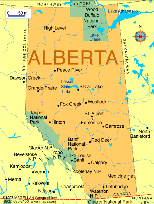
Located in North America, Alberta is a stunning, landlocked Canadian province that boasts natural beauty, diverse regions, and cultural attractions. The province is surrounded by British Columbia to the west and Saskatchewan to the east, the Northwest Territories to the north, and the U.S. state of Montana to the south. Alberta is one of the three prairie provinces in Canada, along with Manitoba and Saskatchewan, and is home to over four million people.
Edmonton, the capital, and Calgary, the largest city, are two major urban centers in Alberta. Edmonton is a vibrant city with a thriving arts and cultural scene, while Calgary is often referred to as the "Gateway to the Rockies" due to its proximity to the Rocky Mountains.
If you want to discover more in-depth information on the province of Alberta, Canada, check out our Alberta Profile!
Plus, test your country knowledge with our world geography quiz, How Well Do You Know Canada?
Alberta Facts: History
The province of Alberta has a rich history that dates back thousands of years, with Indigenous peoples being the first to call the area home. Archaeological evidence shows that the region was inhabited for over 10,000 years, with the first denizens arriving around 8,000 B.C.
European exploration began in the late 1700s, and the fur trade was the primary economic activity until the late 1800s, officially putting Alberta on world maps. On September 1, 1905, Alberta became a province of Canada and has since played a significant role in shaping the country's economy. Today, Alberta is known for its thriving oil and gas industry, which has contributed to the province's economic growth.
Alberta Facts: Geography
The fourth largest province at 661,848 square kilometers, Alberta is home to breathtaking natural beauty, including the Rocky Mountains, which run along the western border of the province and are visible on a detailed map of Alberta. Banff National Park, located in the Rocky Mountains, is one of Canada's most popular tourist destinations. The park offers stunning mountain scenery, hiking trails, and opportunities to see wildlife.
Alberta's northern region is home to vast forests, including the Boreal Forest, which covers more than half of the province. The province's fertile prairies are ideal for agriculture, and Alberta is one of the country's major producers of wheat and canola.
Alberta is divided into regions, each with unique landscapes and attractions, and any topographic map of Alberta provides a detailed view of the province's diverse terrain. Road maps, regional maps, and city maps reveal that Lethbridge and Red Deer are two of the province's major cities, outside of Edmonton and Calgary. Lethbridge is located in southern Alberta and is known for its warm climate and scenic coulees, while Red Deer is located in central Alberta and is home to a thriving arts and culture scene.
Alberta Facts: Tourist Attractions
Alberta is a must-visit destination on any trip to Canada, and many people enjoy exploring the province from afar by looking at an Alberta map. With its diverse regions, including the Rocky Mountains and vast prairies, there is something for everyone in Alberta. Whether you're planning a trip to the wilderness or exploring the province's major cities, Alberta is a stunning destination that showcases the best of Western Canada, including the following.
- Banff National Park: Banff is one of the most famous national parks in Canada, home to stunning mountain scenery, hiking trails, and wildlife.
- Calgary Stampede: A world-famous rodeo and festival that takes place every July in Calgary, promoting Western heritage, culture, and tradition through various events, including rodeo competitions, concerts, and parades.
- West Edmonton Mall: One of the largest shopping centers in the world, located in Alberta's capital city of Edmonton.
- Royal Alberta Museum: Located in Edmonton, the museum showcases the natural and human history of the region, with exhibits on dinosaurs, Indigenous peoples, and the province's oil and gas industry.
- Dinosaur Provincial Park: One of any Canada maps’ UNESCO World Heritage Sites, the area is known for its impressive collection of dinosaur fossils.
- Northern Alberta: The region offers opportunities for fishing, hunting, and outdoor activities in pristine wilderness areas.

People Also Ask...
If you're inspecting this province map of Alberta, you may have some queries about the region. Here are some of the most frequently asked questions, along with their answers.
Why Is Alberta So Famous?
Alberta is famous for its incredible natural scenery, including the Rocky Mountains, national parks, and diverse wildlife. It is also known for its oil and gas industry and its thriving economy, which includes agriculture, forestry, and other industries. Additionally, the province is home to several world-renowned festivals and cultural events, such as the Calgary Stampede.
What Is the Capital of Alberta?
Edmonton is a city located in the central region of the province of Alberta, Canada. It is the fifth largest city in Canada and the capital city of Alberta. The city is situated on the North Saskatchewan River and is known for its beautiful river valley park system.
What Is the Climate Like in Alberta?
Alberta has a continental climate, which means that summers are warm and winters are cold. The province experiences a wide range of temperatures throughout the year, with temperatures reaching as high as 30°C (86°F) in the summer and as low as -40°C (-40°F) in the winter.
|
|
 |
Trending
Here are the facts and trivia that people are buzzing about.


