Weather: Putting Up a Front
Putting Up a Front
What happens when two different air masses meet? You get a front. The following figure gives you an idea the structure of weather fronts. Air masses with contrasting characteristics are pushed together by the winds, so that along a particular line, the weather will change noticeably and sometimes dramatically. As soon as a front passes a particular location, the weather could change from a steamy maritime tropical air mass to a dry, cold continental polar air mass. The transition seldom happens without stormy weather developing. Only rarely is all quiet on the weather front.
Front Row
The naming of fronts is very straightforward. If colder or drier air overtakes warmer, more moist air, that's a cold front. Here a continental polar air mass, or a maritime polar air mass, pushes aside a tropical air mass. Sometimes a continental polar air mass will overtake a maritime polar air mass, and the transition zone is also called a cold front. The temperature could even increase following the passage of a cold front, but the common element is density. A cold front really marks the boundary between more-dense air and less-dense air, with the more-dense air mass overtaking the less-dense air mass.
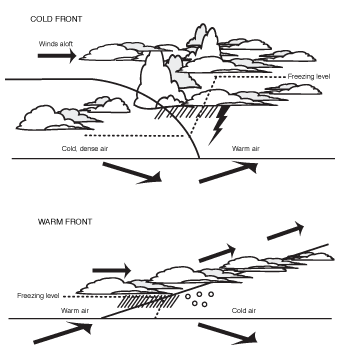
Cross-section of fronts.
Most commonly that involves colder, heavier air overtaking warmer, less dense air. But sometimes, especially during the spring and summer, the continental polar air mass will be warmer than a maritime air mass, because the oceans are cooler than land masses during the warmer time of year. The weather, even in a tropical air mass, could be cloudy and hazy with limited sunshine. The air temperature might be in the 80s, but then a cold front comes through, and the temperature turns warmer!
How can that be? Well, the continental polar air mass is drier, and therefore denser. Air filled with water vapor will weigh less than drier air—the water-vapor molecules weigh less than the other common atmospheric gases. The temperature may not always drop following a cold front's passage, but the dew point always will.
Weather-Speak
A cold front is a front where a colder air mass overtakes and replaces a warmer air mass. A warm front is a front where a warm air mass overtakes and replaces a cold air mass.
Weather-Speak
An occluded front is a front caused by a cold front overtaking a warm front, lifting the warm air above the earth's surface. A stationary front, on the other hand, is not moving.
A warm front leads the way of a tropical air mass. It will push aside a more-dense air mass, typically continental polar or maritime polar. Because a warm front involves less-dense air overtaking more-dense air, it travels more slowly than a cold front. It's tough for something light to shove aside something heavier, so a warm front may plow along at about 20 or 30 mph, while a cold front will move forward at 40 or 50 mph.
In a warm front, the tropical air mass gently rides up over the adjacent cold air mass. In a cold front, the polar air wedges through the lighter air over a much shorter distance. The different lift experienced by the air along the different fronts really accounts for the different types of weather that develop.
Because a cold front can move twice as fast as a warm front, in the course of weather events, cold fronts will be able to catch up with warm fronts. The fronts will cross paths with the cold front catching up. The fronts go through a merger. I don't know if their stock rises after a merger like on Wall Street, but, on Weather Street, the air rises, and we get our dividends in the form of precipitation. This merged front is called an occluded front.
Fronts on parade.
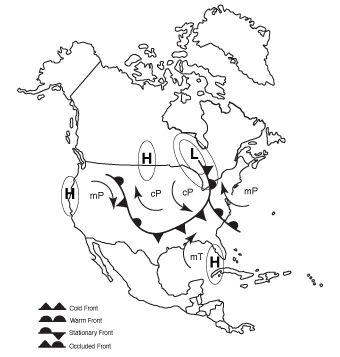
If a front is no longer moving, it's called a stationary front. The continental polar air mass, or the tropical air mass, just doesn't have enough push to move the opposing air mass out of the way. Stationary fronts become real headaches for weather forecasters because the weather turns stormy near the front, and the pattern offers few signs of change. Take a look at the following figure to see how fronts get it together. The fronts drawn with solid triangles are the cold fronts. The fronts with semi-circles are warm fronts. The fronts that have alternating semi-circles and triangles are stationary. Those with semi-circles and triangles on the same side are occluded.
Excerpted from The Complete Idiot's Guide to Weather © 2002 by Mel Goldstein, Ph.D.. All rights reserved including the right of reproduction in whole or in part in any form. Used by arrangement with Alpha Books, a member of Penguin Group (USA) Inc.
Trending
Here are the facts and trivia that people are buzzing about.


